Emerald Sink
Location: Wakulla County, Florida, United States
Emerald Sink is one of the most popular cave-diving sites within the Woodville Karst Plain and serves as an important access point to the vast groundwater network beneath Wakulla County. Located within the Apalachicola National Forest south of Tallahassee, the sink provides divers with access to both upstream and downstream sections of the cave system.
Known for its relatively easy access and connections to the broader Woodville Karst Plain groundwater network, Emerald Sink has become a favorite destination. The system also provides valuable insight into the complex hydrology that links sinkholes, springs, and underwater caves throughout the region.
Today, Emerald Sink remains one of the most frequently visited cave diving sites in the Woodville Karst Plain and an important gateway to understanding the hidden rivers flowing beneath Florida’s Big Bend.
FREE FLORIDA SPRINGS GUIDE
Want to discover more of Florida’s hidden waterways?
Download The 25 Most Notable Springs and Cave Systems in Florida and explore some of the state’s most remarkable spring basins, underwater cave systems, and hidden natural treasures.
✓ Featured springs throughout Florida
✓ Cave systems and exploration highlights
✓ Popular destinations and hidden gems
✓ Instant download
Emerald Sink is not a paddling destination and is not accessible by kayak, canoe, or paddleboard. The site is located inland within the forest and is primarily visited by cave divers, explorers, and individuals interested in Florida’s karst geology.
Visitors can observe the sink basin and surrounding landscape, but the site’s significance lies beneath the surface within the extensive cave system below.
Geological Context
Emerald Sink formed through the dissolution of limestone within the Floridan Aquifer. Over thousands of years, groundwater carved conduits beneath the surface, eventually creating openings that provide access to the underground drainage system.
Unlike springs that discharge water to the surface, Emerald Sink functions a window to the hidden river beneath the ground. Water moves below the surface from the upstream section into the downstream section. The sink also functions as a recharge feature, allowing surface water to enter the aquifer. This relationship helps illustrate the interconnected nature of the Woodville Karst Plain, where sinkholes, springs, disappearing streams, and underwater caves form a single hydrological network.
Water entering Emerald Sink eventually becomes part of the groundwater system feeding major springs such as Wakulla Springs and Sally Ward Spring.
Structure & Layout
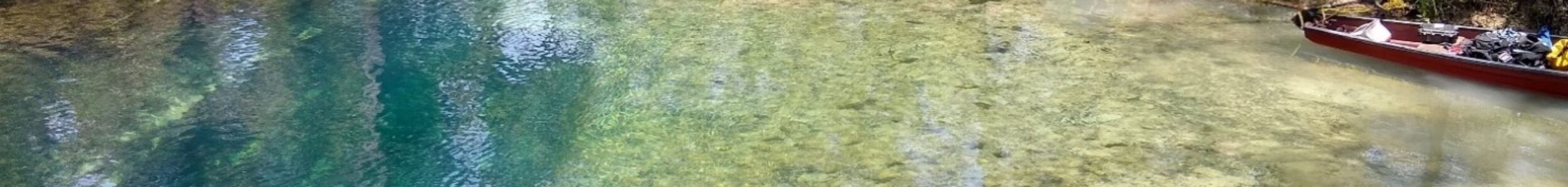
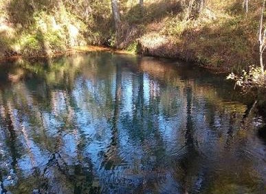
Emerald Sink consists of a circular sinkhole surrounded by forested terrain. The basin provides direct access to the cave system and serves as the staging area for divers entering the site.
The sink’s emerald-colored water gives the site its name and offers a striking contrast against the surrounding landscape.
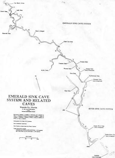
The upstream section of Emerald Sink is generally shallower and is often the first area explored by divers visiting the system. Passage dimensions are relatively comfortable, and the route provides an excellent introduction to cave diving within the Woodville Karst Plain.
The upstream section eventually leads toward portions of the groundwater network associated with the Leon Sinks recharge area.
The downstream section descends significantly deeper and provides access to larger portions of the Woodville Karst Plain cave network. This route has been the focus of extensive exploration efforts and ultimately trends toward the broader groundwater system associated with Wakulla Springs.
The increased depth and complexity of the downstream route make it a more advanced dive than the upstream section and one of the reasons Emerald Sink is highly regarded within the cave diving community.
Exploration History
Emerald Sink has played an important role in exploration of the Woodville Karst Plain. Divers exploring the sink contributed to a growing understanding of the groundwater connections linking numerous sinkholes, springs, and cave systems throughout the region.
Survey and exploration projects have helped document the relationship between Emerald Sink, Leon Sinks, Wakulla Springs, and other components of the Woodville Karst Plain. These discoveries have significantly improved understanding of groundwater flow beneath the Big Bend region.
Today, Emerald Sink continues to serve as both a training site and an important location for cave exploration.
Hydrological Characteristics
Emerald Sink functions primarily as a recharge feature within the Floridan Aquifer.
Water entering the sink moves through submerged conduits and eventually becomes part of the larger groundwater network beneath the Woodville Karst Plain. Dye-trace studies and cave exploration have demonstrated the extensive connections that exist between recharge features such as Emerald Sink and discharge points such as Wakulla Springs.
These connections make Emerald Sink an important location for studying groundwater movement and aquifer dynamics.
Cave Data
Emerald Sink is one of the most accessible cave diving sites within the Woodville Karst Plain and provides divers with a choice between shallow upstream passages and deeper downstream exploration. When you arrive, make sure to look for the sign in sheet at the state parks sign and to note your information.
The upstream route offers a relatively straightforward introduction to the system, while the downstream route provides access to deeper and more extensive portions of the cave network. Divers should select routes appropriate to their training, experience, and equipment.
The surface of the water sits several feet below the ground surface. Steps were constructed onsite to facilitate access to the water. Before driving out, check recent rainfall history. Conditions in the cave near Emerald Sink can quickly deteriorate after extensive rain in the area.
As with all cave dives, proper cave diving certification, planning, and adherence to established safety procedures are essential.
Current Status
Emerald Sink remains one of the most popular cave-diving sites within the Woodville Karst Plain.
The site continues to be used by cave divers. Divers visiting Emerald Sink should familiarize themselves with current access requirements and any registration procedures in effect before entering the system.
Cave divers are required to sign in before diving Emerald Sink. There is a sign in sheet at the state park sign for this purpose. Because procedures may change over time, divers should verify current requirements with the appropriate land managers before visiting the site.
The Hidden Rivers of Florida documents the springs, rivers, sinkholes, caves, and groundwater systems that shape Florida’s landscape. Through exploration, photography, research, and firsthand observation, the project seeks to connect visitors with the hidden waterways flowing beneath the state.
Frequently Asked Questions
Emerald Sink is located within the Apalachicola National Forest in Wakulla County, Florida.
Yes. Emerald Sink is one of the many sinkholes and cave entrances connected to the Woodville Karst Plain groundwater system.
No. Emerald Sink is a swallet and primarily functions as a recharge feature where water enters the groundwater system rather than emerging from it.
The upstream section is generally shallower and trends toward the Leon Sinks recharge area, while the downstream section is deeper and connects to larger portions of the Woodville Karst Plain cave network.
Yes. Emerald Sink is part of the broader groundwater system associated with the Woodville Karst Plain and the Wakulla Springs region.
Dive instructors use Emerald Sink for training and skill development, particularly in the upstream section. However, all diving beyond the cavern zone requires proper cave diving certification. Open water diving is strictly prohibited in Emerald Sink.
Yes. There is a sign in sheet at the state park sign located near Emerald Sink. All divers must sign in prior to entering the water.
No. Emerald Sink is part of the Wakulla Springs State Park system. Solo diving is not permitted in any of the Florida state parks.
Yes. Exploration and survey efforts throughout the Woodville Karst Plain continue to improve understanding of the cave systems connected to Emerald Sink.
Continue Exploring Florida’s Hidden Waters
If you enjoyed the information about this springs, you’ll love the free guide:
The 25 Most Notable Springs and Cave Systems in Florida
From world-famous destinations like Wakulla, Jackson Blue Spring, and Peacock Springs to lesser-known hidden gems, this guide introduces some of Florida’s most fascinating natural wonders.
Download your free copy and continue exploring beyond the surface.
Get the Free Guide →Nearby Springs
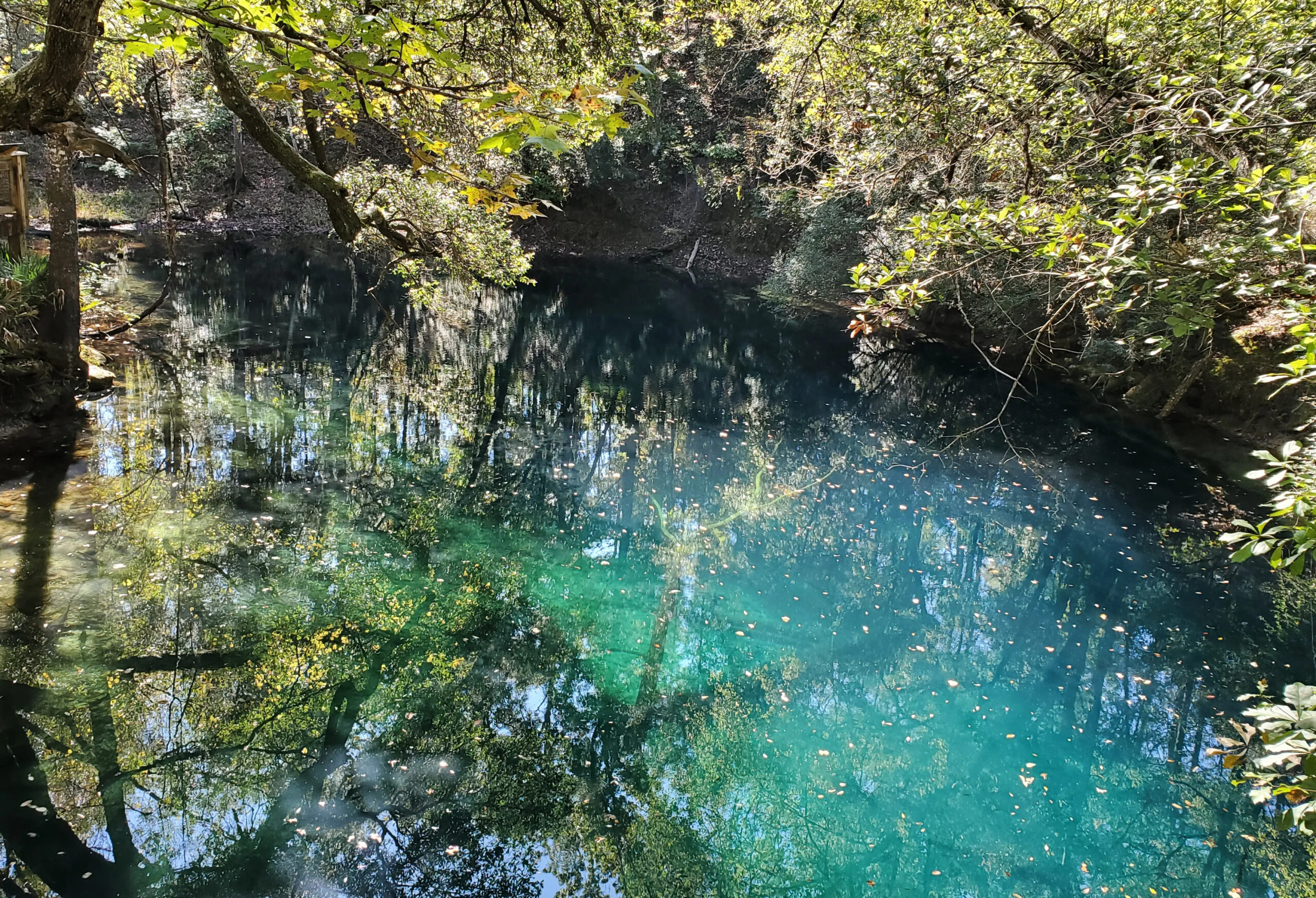
Photo Gallery
Coming soon