Maps of Cave Systems in North Florida
North Florida contains one of the highest concentrations of freshwater cave systems in the world. Beneath the forests, rivers, wetlands, and spring basins of the region lies an extensive network of underwater passages formed within the limestone of the Floridan Aquifer.
Many of these systems have been explored and surveyed by cave divers over several decades. Some are among the most extensively documented underwater cave systems in North America, while others remain only partially explored.
The maps below show the approximate locations of major cave systems and spring basins throughout North Florida. They are intended as general geographic references and do not represent cave survey maps or navigation charts. North Florida cave systems are distributed across four primary regions: the Suwannee River Basin, Santa Fe River Basin, Withlacoochee River Basin, and the Woodville Karst Plain. These regions contain hundreds of springs, sinkholes, and submerged cave passages connected through the Floridan Aquifer.
Please visit the individual spring/cave system pages to view available maps of the hidden rivers.
Suwannee River Basin
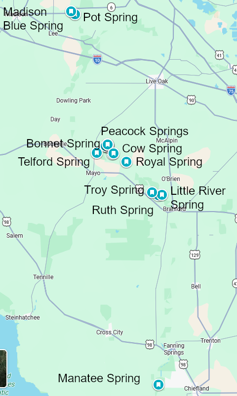
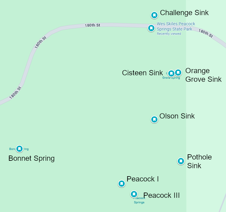
The Suwannee River Basin contains many of Florida’s most recognized cave-diving destinations, including Peacock Springs, Madison Blue Spring, Manatee Blue Spring, Little River Spring, Lafayette Blue Spring, Convict Spring, Royal Spring, Cow Spring, Telford Spring, Luraville Spring, Pot Spring, Bonnet Spring, and Troy Spring.
Santa Fe River Basin
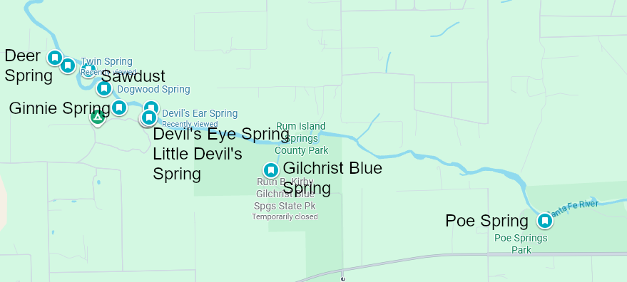
The Santa Fe River Basin contains one of the highest concentrations of springs and underwater cave systems in Florida. Major systems include Ginnie Springs, Devil’s Ear, Devil’s Eye, Little Devil, Hornsby Spring, Poe Spring, Rum Island, and Blue Spring.
Withlacoochee River Basin
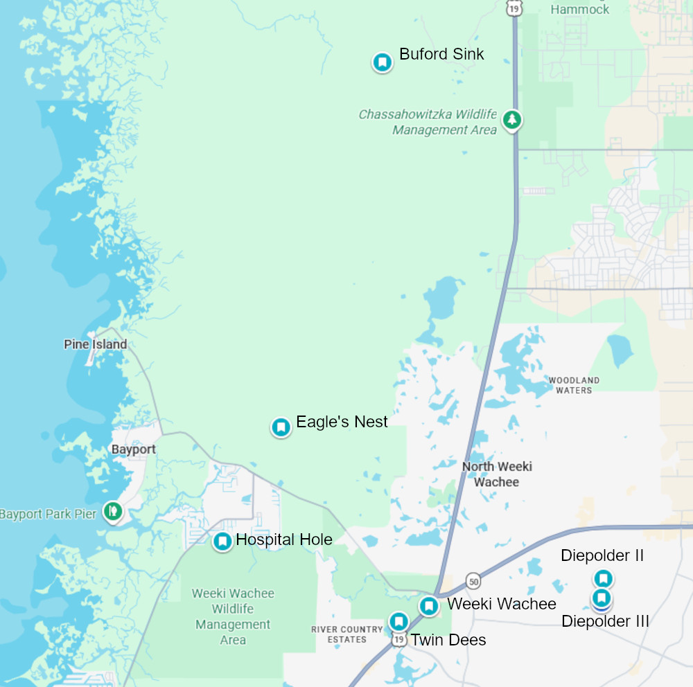
The Withlacoochee River Basin includes several important cave-diving and exploration sites, including Eagle’s Nest, Weeki Wachee Springs, Twin Dees, the Diepolder systems, Citrus Blue Hole, Gum Slough Springs, Hardee Spring, and the Annutteliga Hammock systems.
Woodville Karst Plain
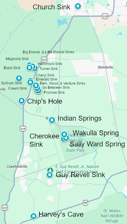
The Woodville Karst Plain contains some of the most extensive underwater cave systems in North America. Major features include Wakulla Springs, Sally Ward Spring, Leon Sinks, Turner Sink, Lost Creek, Chip’s Hole, Guy Revell Sink, Harvey Sink, Church Sink, Emerald Sink, Indian Springs, and Black Creek Rise. The region is characterized by highly interconnected groundwater pathways and extensive cave development.
Cave Systems on the Maps
Suwannee River Basin
- Wes Skiles Peacock Springs State Park
- Madison Blue Spring
- Manatee Blue Springs
- Little River Spring
- Cow Spring
- Telford Spring
- Lafayette Blue Spring
- Convict Spring
- Royal Spring
- Pot Spring
- Luraville Spring
- Bonnet Spring
- Troy Spring
Santa Fe River Basin
- Ginnie Springs
- Devil’s Cave System The Eye and the Ear
- Little Devil
- Hornsby Spring
- Poe Spring
- Rum Island
- Gilchrist Blue Spring
- River Rise
Withlacoochee River Basin
- Eagle’s Nest
- Weeki Wachee Springs
- School Sink
- Hardee Spring
- Twin Dees
- Diepolder Systems
- Citrus Blue Hole
- Gum Slough Springs
- Annutteliga Hammock Systems
Woodville Karst Plain
- Wakulla Springs
- Sally Ward Spring
- Emerald Sink
- Turner Sink
- Leon Sinks
- Indian Springs
- Lost Creek
- Chip’s Hole
- Guy Revell Sink
- Harvey Sink
- Church Sink
- Black Creek Rise
Individual pages for each of the systems listed above are being created and will be posted as they are completed. Please visit again to watch our progress.