
Chassahowitzka Springs
Overview
The Chassahowitzka Springs system is a network of freshwater springs, spring runs, and submerged karst features that feed the Chassahowitzka River along Florida’s Nature Coast. Located in southwestern Citrus County, the system is known for its clear water, shallow river, coastal wetlands, and network of smaller springs that branch away from the main channel. The river flows approximately 5.6 miles from the main spring area to the Gulf, passing through a landscape of cypress, marsh, and salt-tolerant vegetation.
The name Chassahowitzka is often translated as “pumpkin hanging place,” a reference associated with the area’s Indigenous history. Today, the river is best known for paddling, wildlife observation, and access to a series of springs that are scattered throughout the surrounding wetlands.
The Chassahowitzka River is a first-magnitude spring system, with groundwater discharge from a dozen or more springs and smaller vents. The Main Spring forms the headwaters, while Seven Sisters Springs, Crab Spring, Baird Spring, Potter’s Creek Spring, Salt Creek Spring, and other features contribute to the broader network.
The area is also part of a much larger coastal karst landscape. Its springs reveal the connection between the Floridan aquifer, surface waterways, and the wetlands that separate the inland limestone terrain from the Gulf.
Geological Context
The Chassahowitzka Springs system lies within Florida’s karst landscape, where limestone is gradually dissolved by groundwater. Rainfall infiltrates the soil and enters the Floridan aquifer, moving through pores, fractures, and dissolution-enlarged conduits. Where these pathways intersect the surface, groundwater emerges through springs and seepage zones. At Chassahowitzka, groundwater emerges through multiple vents that feed the main river and its tributaries. Some springs form distinct pools, while others emerge through cracks in limestone or beneath the riverbed.
The area’s geology is closely related to its coastal setting. The river is short and shallow, and its lower reaches are influenced by tides and the mixing of freshwater with saltwater. This creates a transition from spring-fed freshwater conditions upstream to a more brackish environment closer to the Gulf. The surrounding wetlands also play an important role. Marshes and swamp forests provide habitat and help filter runoff as water moves through the coastal landscape.
The Chassahowitzka River
The Chassahowitzka River flows approximately 5.6 miles from its main spring area to the Gulf. Unlike many larger Florida rivers, the Chassahowitzka is relatively short and shallow. Mid-channel depths commonly range from about two to nine feet, depending on location and tidal conditions. The river is fed by the Main Spring and numerous smaller springs and seepage areas. These groundwater inputs help maintain relatively stable temperatures and provide much of the river’s freshwater flow. The river winds through cypress wetlands, marshes, and coastal vegetation. Its clear water, shallow passages, and connected spring runs make it a popular destination for canoeing, kayaking, and paddleboarding.
As the river approaches the Gulf, its water chemistry changes. Tidal influence becomes more pronounced, and saltwater mixes with spring water to create an estuarine environment.
Major Springs & Features
Chassahowitzka Main Spring
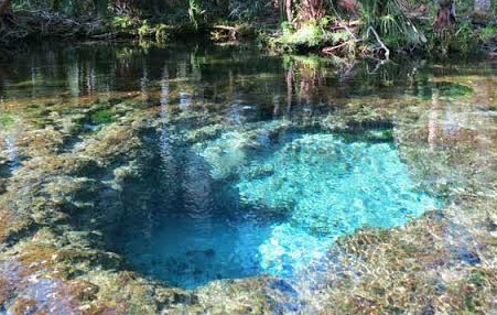
The Main Spring lies near the headwaters of the river, close to the public boat ramp and campground. The spring emerges into a broad pool and provides a major portion of the groundwater feeding the river. It is one of the most accessible spring features in the system and a common starting point for paddlers.
The Main Spring demonstrates how groundwater discharge can create a river that remains clear and cool even during Florida’s warmer months.
Seven Sisters Springs
Seven Sisters Springs is one of the most recognizable features of the Chassahowitzka system. The spring is named for seven circular openings in the limestone. The springs are reached from the river through a narrow, winding waterway. Their sheltered setting and clear water have made them a popular destination for paddlers. The spring openings are part of the region’s broader karst landscape. Groundwater emerges through limestone passages, while the surrounding wetland vegetation creates a distinct setting from the more open main river.
Access conditions can vary with water levels and management rules, so visitors should check current restrictions before entering the area.
Crab Spring
Crab Spring is a smaller spring feature associated with the river’s network of tributaries and spring runs. Like other minor vents in the system, it contributes groundwater to the broader surface-water network and helps demonstrate how the river is sustained by multiple discharge points.
Baird Spring
Baird Spring, also known locally as “the Crack,” is another distinctive feature of the Chassahowitzka area. It is associated with a narrow opening and spring run within the surrounding karst landscape. The feature’s smaller scale contrasts with the Main Spring, but it contributes to the diversity of spring environments within the system.
Potter’s Creek Spring
Potter’s Creek Spring is one of the smaller groundwater features associated with the Chassahowitzka waterways. It contributes to the network of creeks and spring runs that feed the main river.
Salt Creek Spring
Salt Creek Spring lies within the coastal portion of the system, where freshwater discharge interacts with the tidal environment. Water conditions in this area can vary with tides and the mixing of freshwater and saltwater.
These smaller springs and tributaries help make the Chassahowitzka more than a single spring basin. The river is a connected system of groundwater outlets, channels, and coastal wetlands.
Structure & Hydrology
The Chassahowitzka springshed covers a broad area of southwestern Citrus County. Rainfall entering this area replenishes groundwater within the Floridan aquifer, which then moves through limestone conduits and emerges at the springs. The river’s flow is sustained by the combined discharge of the Main Spring and numerous smaller vents. The river is shallow, and water depths vary according to location, tides, and seasonal conditions. Upstream sections are predominantly freshwater, while the lower river transitions toward brackish conditions near the Gulf.
The coastal setting also means that tidal stage can influence water levels and circulation. Spring discharge provides a continuous freshwater input, while the tide changes the movement and mixing of water downstream.
The system illustrates the close relationship between groundwater and surface water in Florida’s karst terrain. The river’s clear channels are visible expressions of groundwater moving through the underlying limestone.
Cave Systems & Exploration
The Chassahowitzka region contains submerged karst features and underwater caves, although not every spring or opening is an accessible cave diving site. The spring network has been explored and documented by divers, researchers, and local naturalists. The focus of much of the region’s exploration has been understanding the connections between spring vents, underwater conduits, and the broader groundwater system.
Paddling & Recreation
Paddling is the primary way many visitors experience the Chassahowitzka River. Canoes, kayaks, and paddleboards can be launched near the main spring area and used to explore the river and its connected waterways. The shallow water, winding channels, and surrounding wetlands provide a different experience from the larger, more developed spring parks. Popular destinations include Seven Sisters Springs and other accessible tributary runs. Some passages are narrow or shallow, and water levels and tides can affect navigation.
Wildlife viewing is another major attraction. Visitors may see turtles, fish, wading birds, and other animals along the river and within the surrounding wetlands. The Chassahowitzka is a sensitive natural system, so visitors should remain within designated access areas, avoid damaging vegetation, and follow local rules regarding private property and wildlife.
- Check river conditions and launch information before your trip.
- Account for tides and shallow passages when paddling.
- Use designated launches and respect private property.
- Avoid damaging aquatic vegetation or disturbing wildlife.
- Be prepared for narrow spring runs and changing water depths.
- Follow local rules and posted restrictions at individual springs.
- Do not assume every spring opening is safe or permitted for diving.
- Dogs are permitted on the river when paddling and canoeing. They are also permitted at the campground.
Wildlife & Habitat
The Chassahowitzka River supports freshwater and estuarine habitats within a relatively short distance. Upstream spring areas provide habitat for fish, turtles, aquatic invertebrates, and submerged vegetation. Farther downstream, saltwater influence increases and the river becomes part of a coastal estuarine environment. The surrounding wetlands support wading birds, raptors, river otters, and other wildlife. The river’s connected waterways provide feeding and movement corridors for aquatic species.
The transition between freshwater and saltwater is particularly important. Changes in salinity and water quality influence the species that can thrive in different parts of the system. Maintaining the health of the river requires protecting the springs and the wetlands that surround them.
Conservation
Wildlife & Habitat
The Chassahowitzka River supports freshwater and estuarine habitats within a relatively short distance.
Upstream spring areas provide habitat for fish, turtles, aquatic invertebrates, and submerged vegetation. Farther downstream, saltwater influence increases and the river becomes part of a coastal estuarine environment.
The surrounding wetlands support wading birds, raptors, river otters, and other wildlife. The river’s connected waterways provide feeding and movement corridors for aquatic species.
The transition between freshwater and saltwater is particularly important. Changes in salinity and water quality influence the species that can thrive in different parts of the system.
Maintaining the health of the river requires protecting the springs and the wetlands that surround them.
Conservation
The Chassahowitzka Springs system is a priority water body for the Southwest Florida Water Management District and is part of the broader Springs Coast watershed. Important environmental challenges include nutrient enrichment, changes in spring flow, water quality degradation, sedimentation, and impacts to aquatic vegetation. The health of the river depends on groundwater conditions throughout its springshed. Development and land use far from the spring openings can influence recharge, runoff, and the quality of water entering the aquifer.
The surrounding coastal wetlands are also important for filtering runoff and providing habitat. Protecting these wetlands helps maintain the natural relationship between the springs, river, and Gulf. Conservation work focuses on monitoring water quality and flow, managing recreation, and protecting the ecological functions of the spring-fed river.
History
The Chassahowitzka area has a long history of Indigenous use and later settlement associated with fishing, hunting, and access to the Gulf Coast. The river’s springs and waterways provided freshwater and routes through the coastal wetlands. Over time, the area became known for its fishing, boating, and outdoor recreation.
Unlike some of Florida’s heavily developed spring destinations, much of the Chassahowitzka landscape remains characterized by wetlands and relatively undeveloped waterways. This has helped preserve its distinctive coastal character. Today, the river is valued for its natural environment, paddling opportunities, and role in the region’s groundwater and wetland systems.
Current Status
The Chassahowitzka Springs system remains an important coastal spring-fed river on Florida’s Nature Coast. The Main Spring and smaller vents continue to provide groundwater to the river, which flows through wetlands and coastal waterways before reaching the Gulf. Public access is available near the main spring area, and paddling remains one of the principal recreational activities. Conditions vary with water levels, tides, weather, and local access rules.
The system faces continuing water quality and habitat challenges, including nutrient enrichment and changes in aquatic vegetation. Monitoring and conservation work are important to maintaining the river’s ecological health. Visitors should check current access conditions before launching, respect posted restrictions, and avoid disturbing the springs and surrounding wetlands.
Return to Florida Cave Systems
Frequently Asked Questions
The system includes approximately a dozen major springs and numerous smaller vents and seepage areas.
The river flows approximately 5.6 miles from the main spring area to the Gulf.
Yes. The Chassahowitzka River is a first-magnitude spring system.
Yes, Seven Sisters is a popular paddling destination reached through a connected waterway. Conditions can vary, and visitors should check current access restrictions and water levels.
The upper river is predominantly freshwater, but the lower river becomes increasingly brackish as it approaches the Gulf.
The river supports groundwater discharge, coastal wetlands, aquatic habitat, and recreation. It also demonstrates the connection between Florida’s karst aquifer and its coastal ecosystems.