
Maps of Springs in Florida’s Nature Coast
Explore the Springs of Florida’s Nature Coast
Florida’s Nature Coast is home to a remarkable collection of freshwater springs, spring-fed rivers, submerged karst features, and coastal waterways. Stretching along the Gulf Coast and into the limestone terrain of west-central Florida, the region offers a diverse range of natural destinations, from the manatee rich waters of Crystal River and Kings Bay to the secluded spring runs of the Chassahowitzka River and the famous Weeki Wachee Springs.
This map guide brings together the major springs and spring systems of Florida’s Nature Coast, helping visitors explore the region’s natural features and find more detailed information about individual sites. Whether you are planning a kayaking trip, looking for a spring to swim or snorkel, observing manatees, or learning about Florida’s underlying karst geology, these maps provide a starting point for exploring the region.
Unlike a single river basin map, a regional Nature Coast guide covers several separate spring systems and watersheds. Groundwater emerges through limestone across the region, feeding rivers, creeks, wetlands, and coastal bays. Understanding these connections helps explain why the Nature Coast contains such a variety of spring environments.
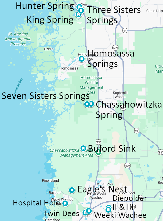
Crystal River / Kings Bay Springs Group
Crystal River and Kings Bay contain one of Florida’s most significant concentrations of springs. Numerous spring vents discharge groundwater into Kings Bay, which connects to the Crystal River and eventually reaches the Gulf of Mexico.
The area’s springs are especially well known for their importance to Florida manatees. During colder weather, manatees gather in the relatively warm waters of the springs, making the region an important wildlife-viewing destination.
Explore the springs and maps:
- Crystal River / Kings Bay Springs Group — Explore the larger spring system, its hydrology, and its relationship to the Crystal River.
- Three Sisters Springs — Learn about the three prominent spring openings, manatee habitat, and viewing opportunities.
Chassahowitzka Springs
The Chassahowitzka Springs system feeds a short, spring-fed river that winds through coastal wetlands before reaching the Gulf. Its waterways include a variety of spring openings, small tributaries, and narrow passages that are popular with kayakers and canoeists.
The system offers a different experience from the more developed spring parks farther north. Much of the surrounding landscape remains characterized by wetlands and natural waterways.
Explore the springs and maps:
- Chassahowitzka Springs — Discover the Main Spring, the river’s hydrology, and its network of smaller springs.
- Seven Sisters Springs — Explore the cluster of limestone spring openings reached by paddling along a narrow waterway.
Weeki Wachee Springs System
Weeki Wachee Springs supplies the Weeki Wachee River, a clear water river that flows west toward the Gulf. The system is known for its spring fed river, paddling opportunities, wildlife, and long history as a Florida attraction.
The surrounding area also contains additional karst features and submerged openings. These features should be distinguished from the main spring itself, as geographic proximity does not necessarily establish an underground connection.
Explore the springs and maps:
- Weeki Wachee Springs — Learn about the main spring, river, geology, history, and recreation.
- Weeki Wachee Springs Cave — Explore the documented cave features associated with the spring.
- Twin Dees Spring (Little Spring) — Discover another spring feature in the broader Weeki Wachee area.
Other Nature Coast Springs & Karst Features
The Nature Coast extends beyond its best known spring groups. Inland limestone terrain, coastal wetlands, and smaller groundwater outlets create a diverse landscape of springs, sinks, and cave features.
Some sites are best understood as individual springs, while others belong to broader karst areas or cave systems. Their regional location does not necessarily mean they share the same springshed or underground drainage route.
Explore additional regional features:
- Eagle’s Nest — A technically demanding underwater cave system in the Nature Coast region.
- Diepolder Cave System — A group of historically important underwater caves with restricted access.
- Gum Slough Springs — A spring fed waterway associated with the Withlacoochee River system.
- Hardee Spring — A spring that flows directly into the Withlacoochee River.
- School Sink — A submerged karst feature associated with the Beacon Woods – Wayne’s World cave area.
- Citrus Blue Hole — A regional spring or karst feature requiring site-specific classification.
- Annutteliga Hammock Systems — A group of karst features within the broader Nature Coast landscape.
These additional features illustrate the variety of groundwater environments found throughout the region. Check the individual site pages for more detailed information about location, access, hydrology, and exploration history.
Planning Your Visit
The Nature Coast offers a range of outdoor experiences, but access varies considerably from one spring system to another. Some springs are reached through developed parks or designated viewing areas, while others require a kayak or canoe. Some cave systems are privately controlled, restricted, or unsuitable for recreational entry.
Depending on the location, visitors may find opportunities for:
- Swimming and snorkeling where permitted
- Kayaking, canoeing, and paddleboarding
- Manatee and wildlife observation
- Hiking and nature photography
- Learning about karst geology and groundwater
- Exploring spring-fed rivers and coastal wetlands
Before visiting, check current park hours, launch locations, water levels, wildlife-protection rules, and access restrictions. Manatee-related rules can affect access to particular areas during winter, and cave-diving sites may have separate permission, training, or access requirements.
Never assume that a visible spring opening leads to a safe or accessible underwater passage. Cave environments can present serious hazards, and entry should be limited to appropriately trained and equipped divers at sites where diving is permitted.
Understanding the Nature Coast’s Spring Systems
Florida’s Nature Coast is a geographic region, not one continuous watershed. Its springs are supplied by groundwater moving through the Floridan aquifer, but the water emerges into several distinct river systems, coastal bays, and wetland networks.
Crystal River and Kings Bay, the Chassahowitzka River, and the Weeki Wachee River are separate spring systems. Other regional karst features may have their own local drainage patterns or connections that require site-specific evidence to establish. This distinction matters when reading spring maps. A map can show which sites are near one another, but geographic proximity alone does not prove that two springs share an underground conduit or springshed.
For more detail, explore the individual spring pages and the regional guides linked below.
Explore More Florida Spring Maps
Looking for springs in other parts of Florida? Continue exploring the regional guides:
- Maps of Springs in North Florida — Explore the springs and river basins of North Florida.
- Maps of Springs in the Florida Panhandle — Discover spring systems and karst features across the Panhandle.
- Maps of Springs in East Central Florida — Explore springs associated with the Middle St. Johns River Basin and nearby systems.
- Florida Springs and Cave System Maps — Start with the broader collection of spring and cave-system maps.
- Florida’s Nature Coast — Explore the regional overview and links to its major spring systems.
Together, these guides provide a regional overview of Florida’s extraordinary network of springs, rivers, and karst landscapes, helping visitors discover everything from popular swimming destinations to remote spring runs and underwater cave systems.
Maps show where Florida’s springs emerge and how the surface landscape is organized. Understanding them also means looking beneath the surface, where groundwater moves through limestone and helps sustain the rivers, wetlands, and coastal ecosystems of the Nature Coast.
For a closer look at Florida’s underwater landscapes and the exploration behind them, read The Hidden Rivers of Florida: Discoveries. The book explores the discoveries, places, and experiences that reveal another side of Florida’s natural history.
Discover the story behind the exploration – The Hidden Rivers of Florida: Discoveries
Amazon | Audible
Available on Kindle Unlimited!
Buy Direct – Signed Copies Available
Free Shipping in the US | Bundle discounts available